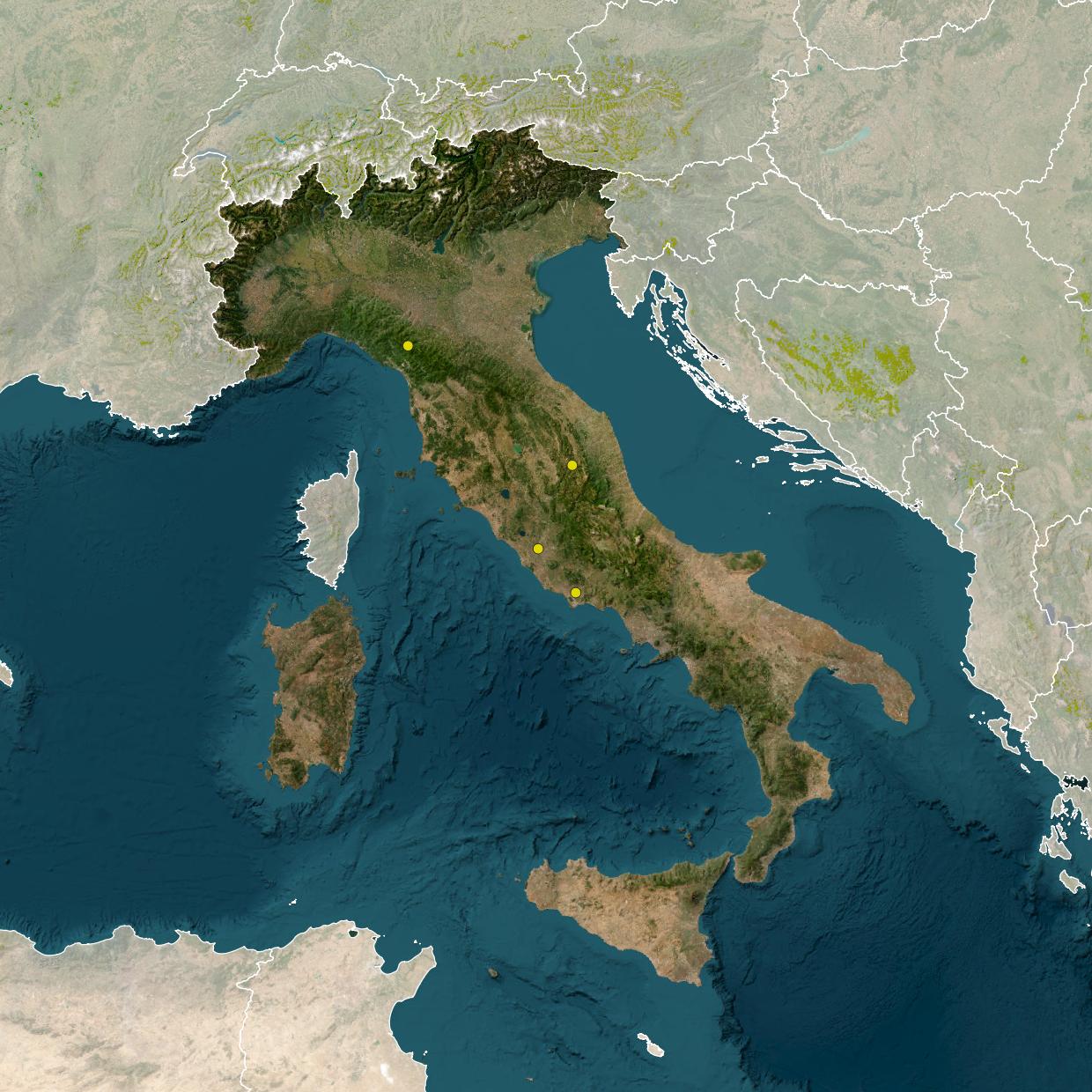
LIFE BEEadapt project selected 5 areas considering their context, land uses, location and administrative condition. It was decided to test the project in urban, peri-urban, rural and protected areas in order to define how the relationship between the different levels of urbanization and the size / types of agricultural land affect the presence of pollinators and their role in actions to adapt to climate change. Moreover, protected areas with different levels of nature protection (both national and regional) have been chosen.
Specifically, the target areas that will be involved in the demonstrative actions (T 5.2) and governance actions are:
Toscana ed Emilia-Romagna
From the combination of natural environment and anthropization comes the mosaic of landscapes that characterizes the territory of the National Park of the Tuscan-Emilian Apennines. It extends over 26,140 hectares in two administrative Regions (Tuscany and Emilia-Romagna), 4 Provinces and 14 municipalities.
The aim of LIFE BEEadapt is to reduce the vulnerability of the target area to these changes for pollinators and promoting the resilience of local agricultural activities and economies, by filling the temporal and spatial gaps in the availability of feeding sources.
The areas of intervention, and the related farming activities, are:
- area of agricultural management of alfalfa and more generally of forage used to feed dairy cows for the production of Parmigiano-Reggiano;
- area of chestnut groves;
- area of agricultural management of specialized blueberries and production of wild blueberries.
The expected results are:
- 15,000 m2 of new green infrastructures;
- 599 ha of grasslands, chestnut groves and blueberries areas pollinators-friendly managed;
- 160 pollinators’ shelters installed;
- 11 farms involved.
Marche
It is located along the mountain ridge of the Umbria-Marche Apennines of central Italy, between about 750 and 1,600 m a.s.l. It extends over 8500 hectares. It includes three Natura 2000 sites. The landforms consist of deep and buried valleys, delimited by very steep slopes, which in the summit areas, soften to form flat or not very steep plateaux. The vegetation is composed of different secondary grasslands (pastures and hay-meadows), deciduous woods (beech, hop-hornbeam, and white oak woods) and croplands. Grasslands are characterized by livestock activity, but also by sites with low disturbance intensity or totally abandoned like the slopes within the “Montagna di Torricchio” Nature Reserve, where only some flat lands are used as hay-meadows. Farming activities are based on sheep and cattle breeding. Woodlands are mainly managed as coppice-with-standards, except inside the Reserve.
The aim of LIFE BEEadapt is to reduce the vulnerability of the target area to these changes for pollinators, by filling the temporal and spatial gaps in the availability of feeding sources.
The expected results are:
- 60 ha of grasslands managed;
- 5000 m2 of new green infrastructures;
- 10 pollinators’ shelters installed;
- 4 farms involved.
Lazio
RomaNatura manages more than 16,000 hectares of protected nature that fall entirely within the territory of Rome: 9 Nature Reserves, 2 Regional Parks, 5 Natural Monuments plus a Marine Reserve, the Marine Protected Area of the Tor Paterno Shoals (1,378 hectares, 6 miles offshore between Ostia and Torvaianica).
The richness of the area managed by the Authority is immense. Its real treasure is represented by ecological niches that count the presence of more than 1,000 plant species, 5,000 species of insects and another 150 species including mammals, birds, amphibians and reptiles. The actions will be defined in the following urban and peri-urban protected areas:
- Decima Malafede Nature Reserve: it is the largest Protected Area in the park system managed by RomaNatura. It encloses in its more than 6,000 hectares a portion of the Roman Campagna included between the southwestern sector of the city, the Vulcano Laziale and the Tyrrhenian coast. The largest wooded areas of the Agro Romano are included in this area and constitute one of the largest lowland forests in the Mediterranean basin;
- the Valle dei Casali Nature Reserve a green corridor within an urban area, the vegetation of which is the result of predominantly agricultural land use, the presence of a dense network of ditches, the Tiber River, and the adjacency to urbanized areas of the city;
- the Tenuta dei Massimi Nature Reserve has an extension of about 868 hectares and lies to the west of the last built-up offshoots of Rome in the Corviale, Borgata del Trullo, and Pisana neighborhoods. The landscape of the protected area is marked by gentle reliefs etched by the hydrographic network of the Fosso della Magliana. It is the typical aspect of the Roman countryside in which vast flat areas occupied mainly by cultivated land and meadow-pastures alternate with hills and small side valleys covered, on the steepest slopes, by woodland formations.
LIFE BeeAdapt project interventions include the application of methodologies for monitoring pollinators and assessing pollination-related ecosystem services in agroecosystems; and interventions aimed at increasing environmental heterogeneity through sustainable planning techniques in rural and urban areas.
The expected results of the project application include:
- the recreation of 220ha of meadows;
- the construction of 15,000 square meters of new green infrastructure;
- the installation of 150 pollinator refuges;
- the involvement of 5 farms.
Municipality of Aprilia
The area is home to DOC, PDO, PGI areas and productions and rich in natural resources. Multi-objective interventions will be developed here, capable of increasing the suitability of the area for pollinators but at the same time aimed at having awareness functions and responding to citizens’ needs for the enjoyment of green spaces.
The expected results of the project’s implementation include:
- the recreation of 84ha of meadows;
- the construction of 15,000 square meters of green infrastructure;
- the installation of 60 pollinator shelters;
- the involvement of 5 farms.
Pontine Plain
The Pontine Plain is an area with a vocation for horticultural, fruit and wine agriculture as well as other crops and represents the third largest Italian province in terms of agricultural turnover. This intensive agricultural activity together with climate change generates a risk factor for pollinators.
The interventions of the LIFE BEEadapt project include both
- the creation of new green infrastructure, such as the honeyflower transects selected by the University of Camerino;
- the adoption of cultivation practices capable of protecting pollinator populations, including through the experimentation of some measures provided by the new Common Agricultural Policy (CAP).
The expected results from the application of the project include:
- the recreation of 866ha of meadows;
- the creation of 10,000 square meters of new green infrastructure;
- the installation of 85 pollinator refuges;
- the involvement of 7 farms.
